Browser GIS for people who work the land
Map, measure and understand any piece of land.
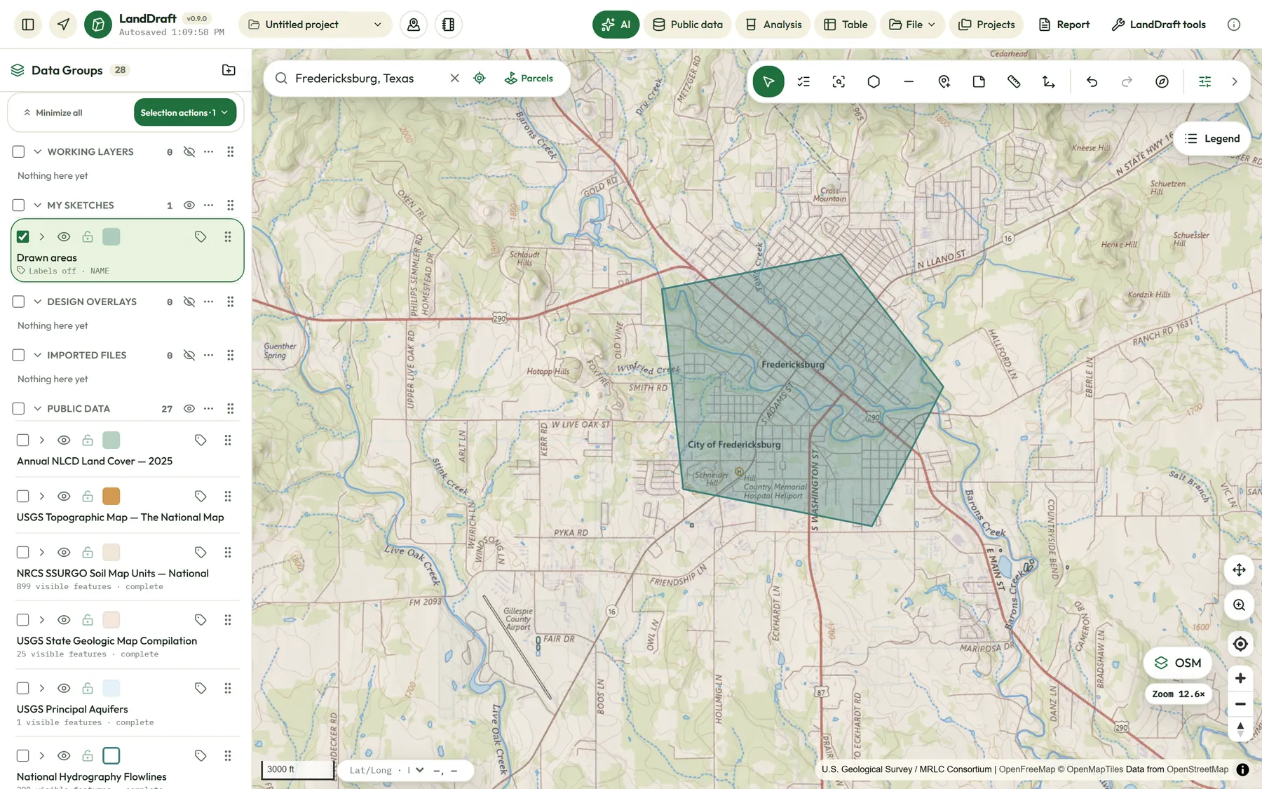
LandDraft puts parcels, flood zones, wetlands, soils, terrain and hundreds of public data layers on one friendly map. Draw your site, see what's on it, and hand your client a clean map, all from your browser.
Free plan, no credit card. Works on desktop, tablet and phone.
Public data from agencies including
- USGS
- FEMA
- US Fish & Wildlife Service
- USDA NRCS
- EPA
- US Census Bureau
- EIA
- Texas state agencies
Who it's for
Built for the people who need answers about a piece of ground
Pick your line of work when you start and LandDraft sets up the layers and tools that matter to you.
Land, real estate and title
Parcels, flood zones, wetlands and soils for a tract in minutes, ready for a client or a closing file.
Oil, gas and energy
Wells, permits, pipelines, power plants and transmission lines over your leases and routes.
Engineering and site development
Terrain, slope, drainage and buildable-area screening before anyone sets foot on site.
Environmental and water
Aquifers, water wells, watersheds, wetlands and regulated facilities in one view.
Hunting and outdoors
Stands, sign, seasons, wind and public hunting land on your phone in the field.
Transportation and logistics
Roads, bridges, clearances and weather along the way for heavy and oversize loads.
Features
Real GIS power, without the wall of toolbars
Everything you need to go from a question about a property to a map you can hand over.
Draw and measure
Sketch areas, lines and points. Get acreage, distance and coordinates as you draw, enter bearings and distances, and undo anything.
Public data, ready to use
Stream federal and state layers for flood, wetlands, soils, geology, water, energy, roads and more. Each layer keeps its source and date.
Texas parcel search
Find parcels by owner, address or county across Texas and drop them straight into your project.
Bring your own files
Import GeoJSON, KML, KMZ, zipped Shapefiles, GPX and coordinate CSV files. Your data lands as normal, editable layers.
Style, label and legend
Color by attribute, set icons, label features and build a clean legend without touching a style sheet.
Spatial analysis
Buffers, intersections, selections, attribute tables, elevation profiles and buildable-area screening that respects slope and setbacks.
Study area reports
Draw a boundary and get a multi-section report on terrain, flood, water, soils, environment and infrastructure, with maps and sources.
Print and export
Lay out print-ready PDF maps with legends and attribution, or export your layers to common GIS formats.
Field and mobile
A phone view built for the field: GPS location, notes and photos on the map, and saved areas for spotty signal.
LandDraft AI
Ask in plain English to find data, filter features, build a selection or explain what a layer means.
Autosave and history
Projects save as you work and sync across devices, with restore points when you need to go back.
Share and collaborate live
Invite people as viewers, as editors on their own copy, or as live collaborators who edit the project with you. Choose exactly which layers they see.
Study area reports
Draw a boundary. Get the whole story.
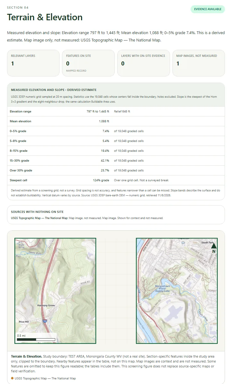
LandDraft checks your site against terrain, flood, water, soils, environmental and infrastructure data and lays it out section by section, with maps, measured numbers and every source named.
- Elevation range, slope bands and relief from USGS terrain data
- Flood zones, wetlands, streams and watersheds on and near the site
- Clear notes on what was measured, what is context and what to verify next
- Report templates for land, energy, development and data center siting
Specialist modules
Add the tools your industry runs on
Modules open focused workspaces on top of your project and add their results back to your main map. Add only the ones you need.
Hunt
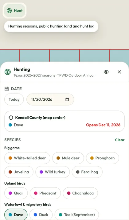
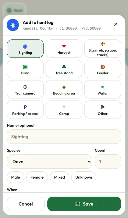
Mark stands, blinds, feeders and sign, check Texas seasons by county, read the wind and keep a hunt log, all from your phone.
Weather Pro
Live radar, storm reports and severe-weather tools over your project, plus forecast and conditions at any point on the map.
Transportation
Check bridges, vertical clearances, weight restrictions, traffic cameras and road conditions for heavy and oversize moves.
Water & hydrogeology
Research groundwater, water wells, aquifers, springs and surface water for a site, then add the findings to your map.
Pipeline
Lay out pipeline routes against terrain, crossings and existing infrastructure in a dedicated engineering workspace.
Oil & Gas (Texas)
Wells, permits and pipelines from Texas public records, with county well data for all 254 counties.
All modules are included with Enterprise, or get every module for $99/mo with the All modules bundle. Oil & Gas (Texas) joins the paid lineup once its data license for commercial use is confirmed. Compare plans
How it works
From address to answer in four steps
- 1
Start a project
Pick your kind of work and LandDraft adds a matching starter set of layers and tools.
- 2
Find your land
Search an address, a parcel or coordinates, then draw your boundary or import a file.
- 3
See what's there
Turn on public data, measure, run analysis or a study area report, and add your notes.
- 4
Deliver
Print a clean map, export the data or send a view-only link to your client.
In the field
Your office map, in your pocket
Open the same project on your phone and LandDraft switches to a simple field view. Find yourself with GPS, drop notes and photos where you stand, and pick up at the desk where you left off.
- Live GPS position and directions to any point
- Notes, photos and markers saved to the project
- Save map areas ahead of time for weak signal
- Pinned tools for the modules you use most
Pricing
Free to map. Pay for the pro tools.
Make and save maps free, forever. Upgrade when you need to print, export, run reports or add modules.
Free
Make and save maps
$0
Free forever
- Create and save up to 5 projects (500 MB)
- Draw, measure, style and label
- Import GeoJSON, KML, KMZ, Shapefile, GPX and CSV
- All public data layers and USGS satellite
- View-only share links
Pro
Most popularFor professionals who deliver maps
$19 /month
or $190 a year, 2 months free
- Everything in Free
- Unlimited projects, 10 GB
- Print and PDF map layouts
- Export GeoJSON, KML, Shapefile, CSV and DXF
- Worldwide high-resolution satellite
Team
Shared work for crews and firms
$39/seat /month
or $390 a year per seat, 2 months free
- Everything in Pro
- Shared team workspace (coming soon)
- Live collaborators and roles
- 25 GB per seat, pooled
- 10 study reports a month
Enterprise
For organizations at scale
Custom
Yearly contract
- Everything in Team, all modules included
- Single sign-on
- Custom data loads and private layers
- Invoicing and yearly contracts
- Uptime commitment and onboarding
Prices in US dollars; sales tax added where it applies. Plans renew until you cancel. Nonprofits and schools save 30%. Full pricing and add-ons
FAQ
Questions people ask
Yes. Creating, drawing on and saving projects is free, with up to five saved projects. Printing, exporting, study reports and specialist modules come with a paid plan or add-on, and you only pay when you need them.
Still wondering about something? Email us
Your next site visit starts on the map
Create a free account and have your first project mapped in minutes.